Local arterial streets and traffic controls (signals and roundabouts) support motorized transportation, such as WTA transit busses, private automobiles, and freight trucks, but also provide benefits to non-motorized users, such as pedestrians and bicyclists. Bellingham requires sidewalks and bikeways on all arterial streets and the non-motorized and motorized networks are integrated with one another. State Highways are managed by the Washington State Department of Transportation (WSDOT), but are also integrated with the local arterial street network. This page focuses on arterial streets and infrastructure as it relates to automobile and freight trucks use and describes the existing and planned arterial street network needed to accommodate Bellingham’s planned growth and development.
Vehicle Network
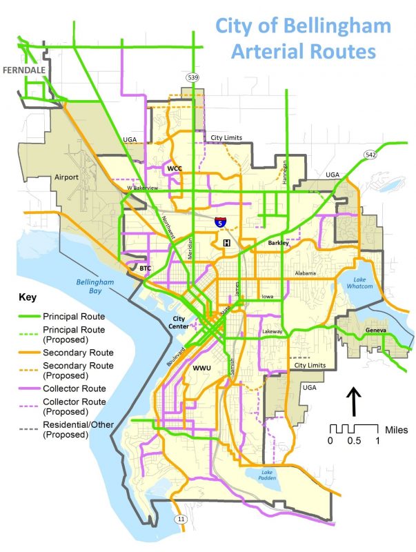
Bellingham’s arterial street network (see map) is locally classified into Principle, Secondary, and Collector arterials, with 2018 lane mile totals as follows:
- Principal Arterial: Major regional transportation corridors and state and federal highways that provide connections into Bellingham from other cities, Whatcom and Skagit Counties, and Canada. Access management is a critical safety issue for these streets.
- Secondary Arterial: Major local transportation corridors that provide connections within and between different parts of Bellingham.
- Collector Arterial: Local transportation corridors that provide connections from neighborhood residential streets to secondary and principal arterial streets.
NOTE: These local classifications are different than federal functional classifications administered by WSDOT.
In 2018, Bellingham’s 268-mile arterial street network includes the following major features:
- 105 lane miles of principal arterial;
- 103 lane miles of secondary arterial;
- 60 lane miles of collector arterial;
- 120 intersection traffic signals;
- 6 multimodal roundabouts;
- 30 pedestrian-activated flashing crosswalks;
- 10 pedestrian hybrid signals [aka – High-Intensity Activated Crosswalks (HAWKs)];
- 26 automated school zone flashers; and
- 2 variable message radar speed signs
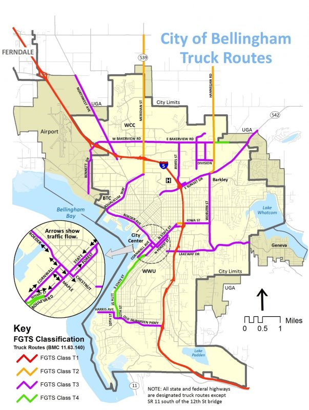
Freight Truck Network
Bellingham has classified several arterial streets and all state and federal highways as Designated Freight Truck Routes, as depicted below. The City encourages major freight shipping companies to direct their drivers to primarily use the designated freight truck routes, but freight delivery trucks cannot be prevented from using any public street for deliveries unless there are weight restrictions on bridges or other public safety access restrictions. As an example, if a family is moving into or out of a house and has hired a moving company to load or unload their belongings, then the large semi-sized moving van must have access to their house via the local residential street. The same is true for large construction vehicles arriving to residential remodel sites.
In 2015, Bellingham worked with WCOG to collect freight truck counts and update Designated Freight Truck Route classifications by annual freight tonnage according to WSDOT Freight and Goods Transportation System requirements, as shown below.
| Bellingham Designated Freight Truck Route Classifications | | |
| Classification | Annual Tonnage | Example (see map) |
| T-1 | > 10 million | Interstate 5 |
| T-2 | 4 – 10 million | SR 539 (Guide Meridian) |
| T-3 | 300,000 – 4 million | SR 542 (Mt. Baker Highway) |
| T-4 | 100,000 – 300,000 | 12th St-State-Boulevard |
| T-5 | < 100,000 | None designated |